Apr
07
2023
By John Tierney
4 min to read
How has the Incultum (incultum.eu) heritage tourism research project (Horizon 2020) influenced our understanding of the archaeology of 19th & 20th century institutional burial practices in Ireland?
The Incultum project has allowed us to add innovative non-invasive survey to our usual work systems; testing an innovative GIS methodology to identify and analyse famine burial features. As field archaeologists the Historic Graves team identified the need to build a Dark History narrative based on scientific systems into our community surveys. Within Incultum and co-funded projects we have tested drone survey and lidar survey (pre-existing and new data collection) for unmarked Famine grave identification with very promising results.
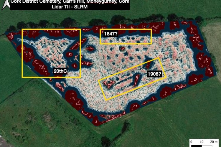
Since 2010 we have been encountering stories of famine related burials in Irish graveyards and considering famine was encountered in Ireland every generation until the 20th century that could be potentially quite a complex story to unpick. Concentrating on a number of Great Famine (1845-1852) burial sites we have, with Incultum funding, developed a better understanding of 19th & 20th century institutional burial practices particularly by identifying and surveying a range of grave types. Working with historian Dr Aoife Bhreatnach in Carr’s Hill cemetery in Cork we became aware of the concept of Monster graves in Irish history. The phrase Monster graves was used in Irish newspapers from about 1847 to 1855 - it was a rhetorical phrase used to describe a form of mass institutional common burial previously unknown in Ireland. The institutional context of the 19th and 20th century burials differentiate burial practices from the previous conflict based mass burials in Ireland. Common graves are those which contain multiple, unrelated individuals and are usually institutional in origin/context.
An RIA 2021 grant to test drone photogrammetry and LIDAR surveys for unmarked grave identification proved surprisingly effective. Because institutional burial is often highly spatially organised we have shown that both narrow and long graves are identifiable with non-invasive techniques. A small number of development-led archaeological excavations have encountered Great Famine era burials in Ireland and Irish archaeologists have published all of these sites. However, there has been little study of the archaeology of Workhouse cemeteries and Incultum has allowed the Eachtra team to commence an innovative survey.
We started the Incultum works in the Summer of 2021 visiting and recording walkover videos (https://www.youtube.com/playlist?list=PLPLPBjRb7FGer45g6Lh6K5GpiHK2njCfm) of just over 20 Workhouse and Mental Hospital cemeteries. In so doing we began to identify unmarked graves of varying shapes and sizes. It is an obvious point, but in field archaeology we have learned that stating the obvious is just good communications - studying unmarked graves in graveyards is a great way to learn about graves and can thereafter be used in the search and identification of unmarked graves outside formal burial grounds.
For us walking up and down the paupers section of Sligo Old cemetery in 2017 was a great learning experience in terms of identifying marked and unmarked graves. Cemetery manager Brian Scanlon showed us how much of the paupers section was covered in graves albeit only a small number were kerbed and had gravestones. As many of the pauper’s graves appear to have been only used once we were seeing graves which had been opened and closed by gravediggers which apparently thereafter were never dug again or indeed never had top up soil added to keep the grave space levelled. An undulating ground surface was formed which we recognised in field walking and which subsequent examination of aerial and satellite images (google earth) also allowed to be identified as rows of grave depressions.
When we tried to apply walkover surveys in Great Famine cemeteries under Incultum we quickly identified a problem. The cemeteries are often large - approx 1 ha in size and also often overgrown by grass tussocks, bracken, and brambles and we had severe difficulty in understanding the ground surface patterns we were encountering. Drone photogrammetry (with Dr Paul Naessens of Western Aerial Surveys) and lidar analysis (with Dr Steve Davis of UCD Archaeologiy Dept) quickly overcame these problems. Site-wide patterns began to emerge when we processed different ground models in QGIS. Photogrammetry is very useful where vegetation is short and can still identify ground surface patterns even with high vegetation but surprisingly a 10 year old TII Lidar dataset has proven to be the most useful way of identifying unmarked graves of various shapes and sizes.
As part of our work for Incultum we presented the current state of our analysis of the archaeology of institutional burial to the Institute of Archaeologists of Ireland at their annual spring conference in late March 2023. A twenty minute walk with 20 slides (see attached) was presented. Here we present an edited version of that slide show with its associated script. Because we are dealing with a number of 20th century institutional burial sites which are considered to be politically sensitive we removed three slides from the IAI presentation. We will present another version of this talk to the EAA in Belfast in Aug/Sept 2023 and we then plan to publish our research in an appropriate journal.
As field archaeologists who work mostly with community volunteers we recognise the opportunities open to us. We tend to listen more than we talk as local historians tell us about their local cases of famine-related burial or burial practices. Incultum has allowed us to take a structured approach from 2021-2024 in recording the stories and the sites we encounter. In particular, it has allowed us to take a very technical approach to the identification and recording of unmarked graves proposing a typology of narrow and long graves as well attempting to distinguish single-use graves from common graves.
Feel free to download the attached pdf and read the accompanying script.
We gratefully acknowledge grants from the RIA, the National Monuments Service (CMF) and Incultum. We also thank the TII archaeologists who gave us access to the 'raw' lidar tiles used in our surveys. Our work in Carr's Hill Cork is being done in tandem with the HSE South. Thanks also to local archaeologists and community members who helped us in the various surveys.
Suggested Reading
Fewer, T. G. 2012 The archaeology of the Great Famine: time for a beginning?
Ruffell, A. et al. 2009 Location and assessment of an historic (150-160 years old) mass grave using geographic and ground penetrating radar investigation, NW Ireland. J Forensic Sci 2009 Mar;54(2):382-94. doi: 10.1111/j.1556-4029.2008.00978.x.
Blog category:


