Aug
02
2023
This graveyard is in the townland of Ballynamona, in the parish of Ballynamona and in the barony of Small County. It is located west of the R513 between Hospital to the south and Herbertstown to the North. At the first crossroads north of Hospital take a left westwards on the L8505. The graveyard and church ruins lie in a field to the west of this road.
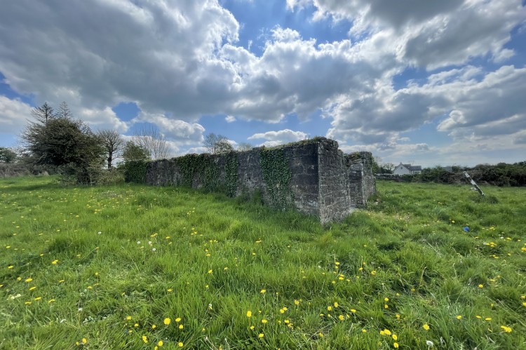
The graveyard is rectangular in shape, with the church ruin positioned slightly northwards of the centre. The graveyard measures ? N-S x ? E-W. It is enclosed by a post-1700 rough limestone wall with the entrance gate at the east side. A stream known as the Ballynamona River flows to the west and Ballynamona Bridge crosses the stream at the crossroads, north of the graveyard.
The name Ballynamona comes from ‘Baile Na Mona’, Baile meaning townland or town, Mona meaning bogland, the town of the bogland (Logainm.ie). Historically the townland has been referred to by its anglicised version, Moortown.
A total of 20 memorials were recorded. Considering the size of the graveyard and the fact that this site has probably been a graveyard since the 14th century and still in use, this is a very low number of memorials. The earliest date recorded during the survey was commemorating Cornelius Ryan who died in 1793 (memorial no. 005). The most recent burial was over fifty years ago, in 1974, (memorial no.19, Historic graves.ie.).
Surnames included O’Sullivan, Riordan, Cremin, O’Mara, Kennedy, O’Grady, Burke, O’Brien, Ryan, Moroney and Malone.
Ballynamona Church and graveyard appear to have been part of Medieval village. In Lewis’s Topographical Dictionary of Ireland (1837), he describes the site as follows ‘on the banks of a small stream, close to the road are the remains of the castle, built by the Raleighs in the reign of Elizabeth 1 and not far from it are the ruins of the old parish church’.
On Cassini's 6 inch map, compiled in the 1930’s, the church is marked as ‘in ruins’, the castle is marked as ‘site of’ Ballynamona Castle. A mill and weir are indicated north of the church, on the northern side of the river.
Even earlier, Simington (1838,110) described a ‘decayed castle, ten cabins and a mill seate’. Westropp (1906-7,184-5) recorded that the castle was levelled before 1840 and folklore records that ‘the church and castle stood in 1827 but both are now in ruins, especially the castle.
Westropp records that a parish church with a date as early as 1302 was located here and identified as Chapel Mora or Moortown, (Archaeology.ie.). This preceded the church which was built by the Raleighs in the 16th century, of which there is little trace.
Interesting Facts
There is a vault in the graveyard dedicated to the Vandeleur family. However, no memorial plaque has survived. The vault sits quite low, constructed of rough stonework and a pitched slate roof. In the 17th, 18th and 19th centuries the Vandeleur family, Dutch in origin, were mainly associated with a large estate near the town of Kilrush, county Clare. Kilrush House was established as the home of the Vandeleur family in 1687. According to the Landed Estates database, a junior branch of the Vandeleurs of Kilrush, a John Ormsby Vandeleur, owned estates in Maddenstown County Kildare and here in Ballynamona. His youngest son, George, inherited 844 acres of the townland of Ballynamona in the mid 19th century. The vault may be the resting place of his family.
A partly surviving stone circle lies east of this graveyard on the other side of the R513, on a gentle west facing slope. It is marked on the Ordnance Survey maps as ‘Stone circle’ and measures 33.5m in diameter. Today it is divided east/west by a modern fence. There are 17 rough boulders all not exceeding 1.2m in height. Its size and shape suggest that the stones are part of a circle, possibly consisting of more than 40 stones. It might very well have been contemporary with the stone circle at Grange, 300m west of Lough Gur, the largest stone circle in Ireland.
18th Century Memorials in Ballynamona Graveyard
005 Cornelius Ryan 1793
007 William Ryan 1796
This post was researched and written as part of a grassroots heritage tourism project (www.incultum.eu) in collaboration with Ballyhoura Development CLG (https://www.ballyhouradevelopment.com/), Cork Co. Council (https://www.corkcoco.ie/en) and Limerick Co. Council (https://www.limerick.ie/council). The stories were initially gathered during a community survey of the graveyard. They form part of the Historic Graves Project Destination for Ballyhoura (https://historicgraves.com/destination/ballyhoura).


