Laois,
Ireland
Coordinates: 52.858000, -6.942000

Summary
Graveyard Code:
LA-STOD
RMP/Site number:
LA032-018002
Townland:
Sleaty
County:
Number of Memorials:
87
Description
Project:

Coordinates: 52.858000, -6.942000
| Photo | Grave | Name | Surname |
|---|---|---|---|
 |
LA-STOD-0076 |
|
|
 |
LA-STOD-0077 |
|
|
 |
LA-STOD-0078 |
|
|
 |
LA-STOD-0079 |
|
|
 |
LA-STOD-0080 | ||
 |
LA-STOD-0081 | ||
 |
LA-STOD-0082 |
|
|
 |
LA-STOD-0083 | ||
 |
LA-STOD-0084 | ||
 |
LA-STOD-0085 | ||
 |
LA-STOD-0086 | ||
 |
LA-STOD-0087 |

![]()
The graveyard is in rural area, surrounded by pasture land.
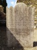
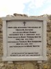
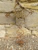
Graveyard contains ruins of medieval church, marked on 1841 OS map as 'Abbey (in ruins)' and on 1908 OS map as 'Church (in ruins)' (National Monument No. 116). The external measurements of the ruins are approx. 14m east-west and 9m north-south; it is composed of coursed limestone blocks apart from the east gable which was rebuilt in sandstone. Granite jambs possibly from earlier church. Also associated: two high crosses, holy well, font and possible souterrain.
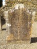
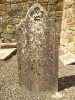
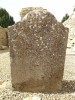
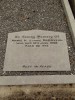
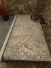
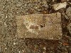
Graveyard contains headstones in varying conditions; many overgrown, leaning and badly worn; all legible graves post-date 1700. Small number of table tombs; generally not in good condition. Several simple metal crosses.
Graveyard has D-shape measuring approx. 38m north-south by 37m east-west; boundary stone wall intact but severely overgrown. Gravel path to church; access via gate and stile across field from road. Ground surface undulating. Ground level within graveyard is higher than that without.